Historical sketch of the rebellion
Item Information
- Title:
- Historical sketch of the rebellion
- Description:
-
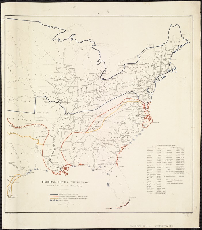
In pursuing Scott’s broad geographic objectives, Union armies made substantial progress in blockading the southeastern coastline and occupying the Mississippi River. This tactic created an economic hardship by greatly diminishing commerce with Europe. With control of the Mississippi Valley, they split the Confederacy, cutting off supply routes particularly from Texas and Arkansas. In order to demonstrate the progress of this strategy, the U.S. Coast Survey published at least seven maps with the same title, “Historical Sketch of the Rebellion,“ each delineating Union military progress. By early 1864, the North had gained control of the entire Mississippi River Valley, blocked most southern ports, and had occupied much of the Texas, Georgia, South Carolina, North Carolina and Virginia coastal areas.
- Creator:
- Lindenkohl, H. (Henry)
- Name on Item:
-
Drawn by H. Lindenkohl ; Chas. G. Krebs, lith.
- Date:
-
[1864]
- Format:
-
Maps/Atlases
- Location:
-
Boston Public Library
Norman B. Leventhal Map Center - Collection (local):
-
Norman B. Leventhal Map Center Collection
- Subjects:
-
United States--History--Civil War, 1861-1865--Maps
- Places:
-
- Extent:
- 1 map : col. ; 47 x 45 cm.
- Terms of Use:
-
No known copyright restrictions.
No known restrictions on use.
- Publisher:
-
[S.l.] :
Office of the U.S. Coast Survey
- Scale:
-
Scale 1:5,850,000.
- Language:
-
English
- Notes:
-
Limit of loyal states in July, 1861, limit of territory controlled by U.S. forces July 31st 1863, [and] limit of territory gained from July 31st 1863 to Jan. 1st 1864 indicated by colored lines. Small ships denote the extent of the naval blockade.
"Population census 1860" in the lower right corner.
See also Civil War Maps entry nos. 34, 35, 36, 39, 40 and 40.1.
Description derived from published bibliography.
- Notes (date):
-
This date is inferred.
- Notes (exhibitions):
-
Exhibited: "Torn in Two: The 150th Anniversary of the Civil War" organized by the Norman B. Leventhal Map Center at the Boston Public Library, 2011.
- Identifier:
-
06_01_006854
- Call #:
-
G3701.S5 1863 .L5
- Barcode:
-
39999059028736
- LCCN:
-
99447147


