Worcester County : Essex County
Item Information
- Title:
- Worcester County : Essex County
- Title (uniform):
-
Weekly messenger
- Description:
-
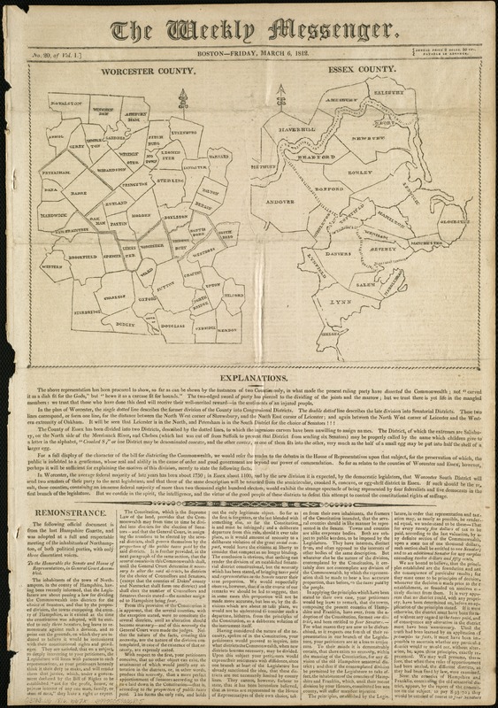
During the first weeks of March 1812, several Boston newspapers published this map which inspired the creation of the “gerrymander” cartoon. The map illustrates the new senatorial districts in Worcester and Essex Counties. The article explains that these counties had an “immense Federal majority,” but would likely elect four Federalists and five Jeffersonian Democrat-Republicans, the party of Governor Elbridge Gerry. In criticizing this redistricting plan, the influential Federalist newspapers commented that the ruling party carved the Commonwealth, “not … as a dish fit for Gods’ but ‘hewn it as a carcase fit for hounds.’”
- Date:
-
1812
- Format:
-
Maps/Atlases
- Location:
-
Boston Public Library
Norman B. Leventhal Map Center - Collection (local):
-
Norman B. Leventhal Map Center Collection
- Subjects:
-
Worcester County (Mass.)--Maps
Essex County (Mass.)--Maps
- Places:
-
Essex (county)
Worcester (county)
- Extent:
- 2 maps on 1 sheet ; 20 x 16 cm or smaller, on sheet 49 x 34 cm
- Terms of Use:
-
No known copyright restrictions.
No known restrictions on use.
- Publisher:
-
Boston :
[s.n.]
- Scale:
-
Scale not given.
- Language:
-
English
- Notes:
-
Maps of Worcester and Essex counties, appearing in the March 6, 1812 (no. 20 of v. 1) edition of The Weekly Messenger.
- Notes (exhibitions):
-
Exhibited: "America Votes: Mapping the Political Landscape" organized by the Norman B. Leventhal Map Center at the Boston Public Library, 2012.
- Identifier:
-
06_01_006580
- Call #:
-
G3763.W6 1816 .W67x
- Barcode:
-
39999059026805


