The cotton kingdom
Item Information
- Title:
- The cotton kingdom
- Description:
-
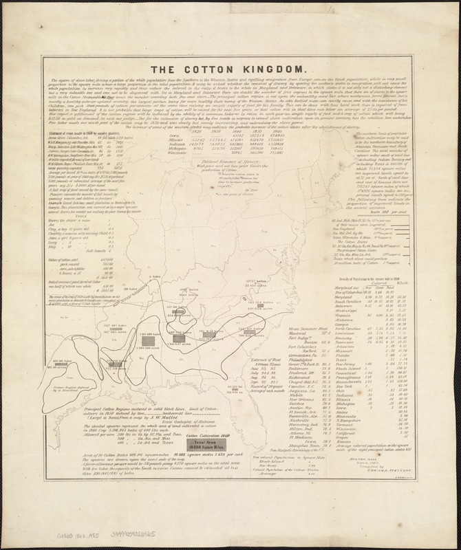
During the antebellum period, cotton was considered “king“ in the South, as it was the region’s predominant cash crop. Cotton cultivation began in coastal South Carolina, but with the invention of the cotton gin in 1793, spread rapidly as far west as Texas. Requiring fertile soil and an extensive growing season, there was a northern geographic limit to cotton cultivation. This boundary is suggested by the “mean summer temperature“ line on this detailed statistical map delineating the major areas of cotton production. Published by Brookline resident Edward Atkinson, this map was one of many documents about cotton that he authored. An executive officer for a number of Boston area textile factories, Atkinson was also an ardent abolitionist and wrote numerous tracts advocating cotton cultivation with free labor.
- Creator:
- Atkinson, Edward, 1827-1905
- Name on Item:
-
compiled by Edward Atkinson.
- Date:
-
[1863]
- Format:
-
Maps/Atlases
- Location:
-
Boston Public Library
Norman B. Leventhal Map Center - Collection (local):
-
Norman B. Leventhal Map Center Collection
- Subjects:
-
Cotton trade--Southern States
Slavery--Southern States
Southern States--Maps
- Places:
-
Southern United States (area)
- Extent:
- 1 sheet ; 53 x 42 cm.
- Terms of Use:
-
No known copyright restrictions.
No known restrictions on use.
- Publisher:
-
Boston, Mass :
s.n.
- Language:
-
English
- Notes:
-
Includes map and statistics relating to crops, temperature, population, etc.
"Boston, Mass[.] March, 1863. Compiled by Edward Atkinson."
- Notes (date):
-
This date is inferred.
- Notes (exhibitions):
-
Exhibited: "Torn in Two: The 150th Anniversary of the Civil War" organized by the Norman B. Leventhal Map Center at the Boston Public Library, 2011.
Exhibited: "Crossing Boundaries: Art // Maps" organized by the Norman B. Leventhal Map & Education Center at the Boston Public Library, 2018-2019.
- Identifier:
-
06_01_006560
- Call #:
-
G3860 1863 .A85
- Barcode:
-
39999059026565


