Map of battles on Bull Run, near Manassas, on the line of Fairfax & Prince William Counties, in Virginia, fought between the forces of the Confederate States and of the United States of America : Gene'ls. Beauregard and Johnston commanding the Confederate and Genl. McDoweel, the United States forces, on the 21st of July, 1861, from 7 a.m.-9 p.m
Item Information
- Title:
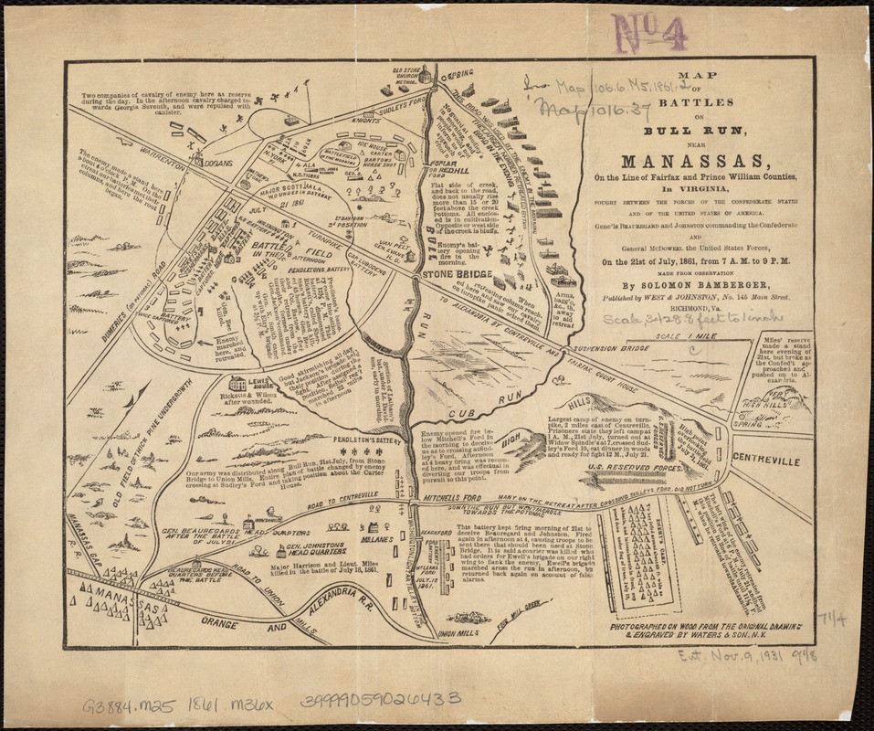
- Map of battles on Bull Run, near Manassas, on the line of Fairfax & Prince William Counties, in Virginia, fought between the forces of the Confederate States and of the United States of America : Gene'ls. Beauregard and Johnston commanding the Confederate and Genl. McDoweel, the United States forces, on the 21st of July, 1861, from 7 a.m.-9 p.m
- Description:
-
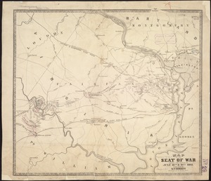
Torn in Two: The first major battle of the war occurred July 21, 1861, near Manassas, Virginia, an important railroad junction approximately 25 miles west of Washington, DC. This map, published in Richmond, is one of only a few examples of battle maps produced by a commercial publisher within the Confederacy. This relatively simple diagram used pictorial symbols and text to provide a detailed account of the battle. As indicated in the map’s title, the battle was known by various names. The Confederates, who named battles for nearby towns, knew it as the Battle of Manassas. For the Union army, which often named battles for nearby rivers or streams, it was the Battle of Bull Run.
- Creator:
- Bamberger, Shelomoh, ha-Le?vi
- Name on Item:
-
made from observation by Solomon Bamberger ; photographed on wood from the original drawings & engraved by Waters & Son.
- Date:
-
[1861]
- Format:
-
Maps/Atlases
- Location:
-
Boston Public Library
Norman B. Leventhal Map Center - Collection (local):
-
Norman B. Leventhal Map Center Collection
- Subjects:
-
Bull Run, 1st Battle of, Va., 1861--Maps
Manassas (Va.)--Maps
- Places:
-
Manassas (independent city)
Prince William (county)Manassas National Battlefield Park (national park)
- Extent:
- 1 map ; 19 x 24 cm.
- Terms of Use:
-
No known copyright restrictions.
No known restrictions on use.
- Publisher:
-
Richmond, Va :
West & Johnston
- Scale:
-
Scale ca. 1:42,240.
- Language:
-
English
- Notes:
-
Relief shown pictorially.
Includes text.
- Notes (date):
-
This date is inferred.
- Notes (exhibitions):
-
Exhibited: "Torn in Two: The 150th Anniversary of the Civil War" organized by the Norman B. Leventhal Map Center at the Boston Public Library, 2011.
- Identifier:
-
06_01_006540
- Call #:
-
G3884.M25 1861 .M36x
- Barcode:
-
39999059026433

![Map of the battlefield of Bull Run, Virginia. Brig. Gen. Irvin McDowell commanding the U.S. forces, Gen. [P.] G.T. Beauregard commanding the Confederate forces, July 21st 1861](https://bpldcassets.blob.core.windows.net/derivatives/images/commonwealth:ww72bp023/image_thumbnail_300.jpg)