Charleston Harbor and its approaches showing the positions of the Rebel batteries
Item Information
- Title:
- Charleston Harbor and its approaches showing the positions of the Rebel batteries
- Description:
-
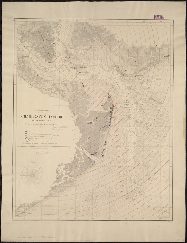
Anticipating war, the U.S. Coast Survey was one of the few agencies able to provide accurate nautical charts and topographic maps before and during the war. Led by Alexander Dallas Bache, the nation’s foremost scientist and great-grandson of Benjamin Franklin, the agency’s primary mission was to chart the nation’s coastal waters, and by the 1850s was beginning to produce detailed nautical charts for most of the Atlantic and Gulf coastal waters. One example is this chart of South Carolina’s Charleston Harbor published in 1863. Utilizing an 1858 chart, which was based on detailed hydrographic and topographic surveys conducted in the early 1850s, this version was overprinted to show forts, “National“ and “Rebel“ trenches and batteries, and positions of the attacking fleet as of September 7, 1863.
- Creator:
- United States Coast Survey
- Date:
-
[1863]
- Format:
-
Maps/Atlases
- Location:
-
Boston Public Library
Norman B. Leventhal Map Center - Collection (local):
-
Norman B. Leventhal Map Center Collection
- Subjects:
-
Charleston Harbor (S.C.)--History--19th century--Maps
Charleston Region (S.C.)--History--19th century--Maps
- Places:
-
Charleston (county)Charleston Harbor (bay)
Charleston (county)Charleston
- Extent:
- 1 map : col., 61 x 47 cm.
- Terms of Use:
-
No known copyright restrictions.
No known restrictions on use.
- Publisher:
-
New York :
Lith. of J. Bien
- Scale:
-
Scale 1:30,000.
- Language:
-
English
- Notes:
-
Another issue.
Shows roads, railroads, houses, vegetation, a street plan of Charleston, drainage, soundings, and shoals.
Overprinted to show 1/4-mile concentric circles centered on St. Michaels, Charleston; positions occupied by the Union Army and Navy; "Rebel batteries in possession of National forces [and] batteries still held by the Rebels [on] Sept. 7th 1863." Union positions are based "on the authority of Maj. T.B. Brooks."
Description derived from published bibliography.
- Notes (date):
-
This date is inferred.
- Notes (exhibitions):
-
Exhibited: "Torn in Two: The 150th Anniversary of the Civil War" organized by the Norman B. Leventhal Map Center at the Boston Public Library, 2011.
- Identifier:
-
06_01_006533
- Call #:
-
G3912.C4S5 1863 .U5
- Barcode:
-
39999059026409
- LCCN:
-
99448828


