Map of the United States, showing by colors the area of freedom and slavery, and the territories whose destiny is yet to be decided : exhibiting also the Missouri compromise line, and the routes of Colonel Fremont in his famous explorations : with important statistics of the free and slave states
Item Information
- Title:
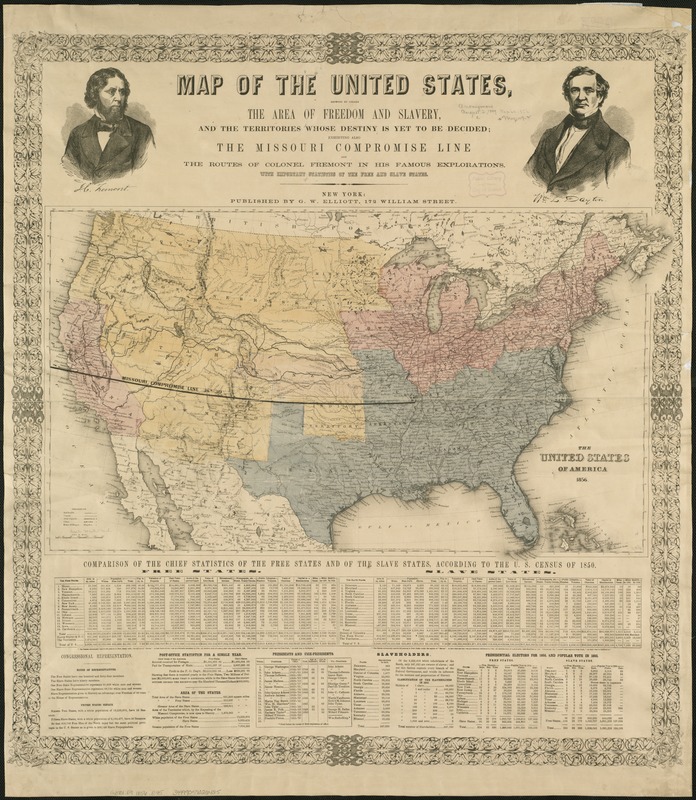
- Map of the United States, showing by colors the area of freedom and slavery, and the territories whose destiny is yet to be decided : exhibiting also the Missouri compromise line, and the routes of Colonel Fremont in his famous explorations : with important statistics of the free and slave states
- Description:
-
Published as a campaign poster supporting the Republican Party's first presidential bid in 1856, this broadside provides a commentary on the geographical sectionalism that was polarizing the nation. Using 1850 census data, it tabulated the demographic and economic differences between free and slave states, highlighting political concerns that the balance of Congressional power would shift as newly acquired western territories were admitted as states into the Union. The map clearly marked the 1820 Missouri Compromise line, which had defined the boundary between free and slave states. However, the passage of the 1854 Kansas-Nebraska Act nullified this long-standing compromise line, and potentially opened the entire western territory to slavery because it sanctioned “popular sovereignty“ whereby citizens of each territory could vote on the slavery issue.
- Creator:
- Elliott, G. W.
- Date:
-
[1856?]
- Format:
-
Maps/Atlases
- Location:
-
Boston Public Library
Norman B. Leventhal Map Center - Collection (local):
-
Norman B. Leventhal Map Center Collection
- Subjects:
-
Slavery--United States--Maps
Discoveries in geography--American--Maps
United States--Discovery and exploration--Maps
United States--Maps
- Places:
-
- Extent:
- 1 map : hand col. ; 36 x 65 cm., on sheet 80 x 73 cm.
- Terms of Use:
-
No known copyright restrictions.
No known restrictions on use.
- Publisher:
-
New York :
G.W. Elliott
- Scale:
-
Scale [ca. 1:9,200,000]
- Language:
-
English
- Notes:
-
Relief shown by hachures.
Hand colored.
Includes text, tables, ports., and decorative border.
- Notes (exhibitions):
-
Exhibited: "Torn in Two: The 150th Anniversary of the Civil War" organized by the Norman B. Leventhal Map Center at the Boston Public Library, 2011.
- Identifier:
-
06_01_006539
- Call #:
-
G3701.E9 1856 .E45
- Barcode:
-
39999059026425


