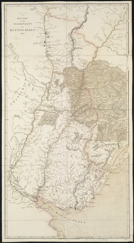
A map of part of the Viceroyalty of Buenos Ayres 1806
Item Information
- Title:
- A map of part of the Viceroyalty of Buenos Ayres 1806
- Date:
-
1806
- Format:
-
Maps/Atlases
- Location:
-
Boston Public Library
Norman B. Leventhal Map Center - Collection (local):
-
Norman B. Leventhal Map Center Collection
- Subjects:
-
Argentina--Maps
Corrientes (Argentina : Province)--Maps
Entre Ríos (Argentina)--Maps
- Places:
-
Argentina
- Extent:
- 1 map ; 97 x 53 cm.
- Terms of Use:
-
No known copyright restrictions.
No known restrictions on use.
- Publisher:
-
London :
A. Arrowsmith
- Scale:
-
Scale [1:2,110,000].
- Language:
-
English
- Notes:
-
Greenwich meridian.
Relief shown by hachures and shading. Depths shown by soundings.
Part of Argentina, including Rio Paraguay and Rio Uruguay, now the Entre Rios and Corrientes regions.
Cataloging, conservation, and digitization made possible in part by The National Endowment for the Humanities: Exploring the human endeavor.
- Identifier:
-
06_01_006469
- Call #:
-
G5350 1806 .M36
- Barcode:
-
39999059025831