Lloyd's map of the lower Mississippi River from St. Louis to the Gulf of Mexico
Item Information
- Title:
- Lloyd's map of the lower Mississippi River from St. Louis to the Gulf of Mexico
- Description:
-
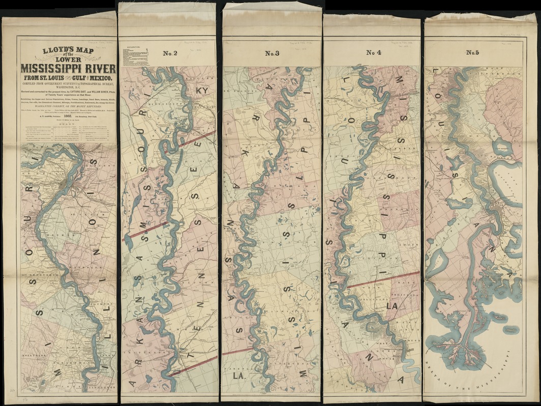
Southern settlement patterns were primarily rural and agricultural. Although some railroads existed by the 1850s, mileage and connectivity were limited. There was heavy reliance on river transportation as suggested by this multi-sheet map of the Mississippi River. Cutting through the heart of the country, the Mississippi created alluvial soils ideal for commercial agriculture. Near New Orleans sugar was the primary crop, while upriver in northern Louisiana and in Mississippi, Arkansas, and Tennessee, cotton was the major cash crop. While individual plantations are not associated with either crop, plantation and landowner names identify the large landholdings lining the river’s edge. One of particular note is Jefferson Davis’ plantation, which is labeled as Davis Bend or Hurricane Plantation, located 20 miles downstream from Vicksburg on a large meander of the river. Crossing Boundaries exhibition: Shown on this map as a dense block of squares between Lake Ponchartrain and the Mississippi River, New Orleans was the center of trade from plantations that are visible as long lots bordering the river to the north. Canals and ditches were developed in an attempt to mitigate flooding, even in the 19th century. Today, as a result of severe storms and rising sea levels, Louisiana’s wetlands are disappearing faster than any on the planet.
- Creator:
- Lloyd, James T.
- Name on Item:
-
compiled from government surveys in the Topographical Bureau, Washington, D.C. ; revised and corrected to the present time, by Captains Bart. and William Bowen, pilots of twenty years' experience on that river.
- Date:
-
1862
- Format:
-
Maps/Atlases
- Location:
-
Boston Public Library
Norman B. Leventhal Map Center - Collection (local):
-
Norman B. Leventhal Map Center Collection
- Subjects:
-
Mississippi River--Maps
- Places:
-
Mississippi River
- Extent:
- 1 map on 5 sheets : col. ; 408 x 26 cm., sheets 30 x 99 cm.
- Terms of Use:
-
No known copyright restrictions.
No known restrictions on use.
- Publisher:
-
New York :
J.T. Lloyd
- Scale:
-
Scale [ca. 1:316,800].
- Language:
-
English
- Notes:
-
Map printed in five segments.
Hand colored.
Shows distances from New Orleans to St. Louis in five mile increments.
- Notes (exhibitions):
-
Exhibited: "Torn in Two: The 150th Anniversary of the Civil War" organized by the Norman B. Leventhal Map Center at the Boston Public Library, 2011.
Exhibited: "Crossing Boundaries: Art // Maps" organized by the Norman B. Leventhal Map & Education Center at the Boston Public Library, 2018-2019.
- Identifier:
-
06_01_006427
- Call #:
-
G4042.M5 1862 .L56
- Barcode:
-
39999059025567


