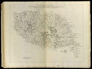
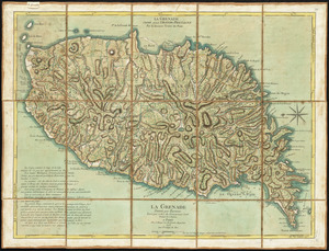
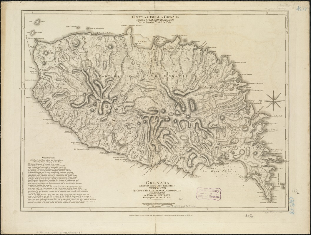
Carte de l'Isle de la Grenade cédée a la Grand Bretagne par le dernier traité de paix = Grenada divided into its parishes : surveyed by order of his excellency Governor Scott
This map is also available in American Revolutionary Geographies Online (ARGO), a collections portal especially built for material relating to the American Revolutionary War Era. Visit ARGO to learn more about this item and explore the historical geography of North America in the late eighteenth century.
Item Information
- Title:
- Carte de l'Isle de la Grenade cédée a la Grand Bretagne par le dernier traité de paix = Grenada divided into its parishes : surveyed by order of his excellency Governor Scott
- Title (alt.):
-
Grenada divided into its parishes
- Creator:
- Jefferys, Thomas, d. 1771
- Name on Item:
-
and engraved by Thomas Jefferys.
- Date:
-
1775
- Format:
-
Maps/Atlases
- Location:
-
Boston Public Library
Norman B. Leventhal Map Center - Collection (local):
-
Norman B. Leventhal Map Center Collection
- Subjects:
-
Grenada--Maps--Early works to 1800
- Places:
-
Grenada
- Extent:
- 1 map ; 45 x 61 cm.
- Terms of Use:
-
No known copyright restrictions.
No known restrictions on use.
- Publisher:
-
London :
Printed for Robt. Sayer
- Scale:
-
Scale [ca. 1:70,000]
- Language:
-
English
French
- Notes:
-
Relief shown by hachures; depths by soundings.
Shows buildings, fortifications, anchorages, roads, etc. and includes descriptive note.
Oriented with north to the left.
Place names French, note, etc. in English.
"Printed for Robt. Sayer, Map and Printseller, no. 53 in Fleet Street, as the Act directs 20 Feby. 1775."
Prime meridians: Ferro and London.
Appear in the author's West-Inda atlas. London : Robert Sayer and John Bennett, 1783 [i.e. 1788].
Cataloging, conservation, and digitization made possible in part by The National Endowment for the Humanities: Exploring the human endeavor.
- Identifier:
-
06_01_006376
- Call #:
-
G5130 1775 .J44
- Barcode:
-
39999059025237