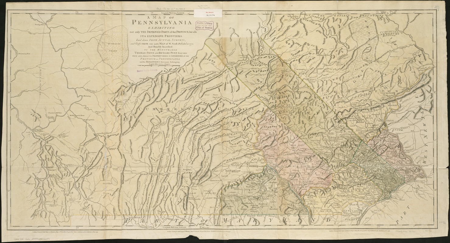
A map of Pennsylvania exhibiting not only the improved parts of that Province, but also its extensive frontiers : laid down from actual surveys, and chiefly from the late map of W. Scull published in 1770; and humbly inscribed to the Honorable Thomas Penn and Richard Penn, Esquires, true and absolute proprietaries & Governors of the Province of Pennsylvania and the territories thereunto belonging
This map is also available in American Revolutionary Geographies Online (ARGO), a collections portal especially built for material relating to the American Revolutionary War Era. Visit ARGO to learn more about this item and explore the historical geography of North America in the late eighteenth century.
Item Information
- Title:
- A map of Pennsylvania exhibiting not only the improved parts of that Province, but also its extensive frontiers : laid down from actual surveys, and chiefly from the late map of W. Scull published in 1770; and humbly inscribed to the Honorable Thomas Penn and Richard Penn, Esquires, true and absolute proprietaries & Governors of the Province of Pennsylvania and the territories thereunto belonging
- Creator:
- Robert Sayer and John Bennett (Firm)
- Date:
-
1775
- Format:
-
Maps/Atlases
- Location:
-
Boston Public Library
Norman B. Leventhal Map Center - Collection (local):
-
Norman B. Leventhal Map Center Collection
- Subjects:
-
Pennsylvania--Maps--Early works to 1800
Pennsylvania--Administrative and political divisions--Maps--Early works to 1800
- Places:
-
Pennsylvania
- Extent:
- 1 map : col. ; 68 x 132 cm.
- Terms of Use:
-
No known copyright restrictions.
No known restrictions on use.
- Publisher:
-
London :
Printed for Robt. Sayer & J. Bennett
- Scale:
-
Scale ca. 1:365,000.
- Language:
-
English
- Notes:
-
Covers part of west New Jersey.
Relief shown pictorially.
Shows county boundaries, names of towns, roads, and places of interest.
Appears in Thomas Jefferys' The American atlas, or, a geographical description of the whole continent of American... 1775. London: R. Sayer and J. Bennett, 1776. Map # 20.
Prime meridian: London.
Imprint on each sheet.
- Identifier:
-
06_01_006316
- Call #:
-
G3820 1775 .R63
- Barcode:
-
39999059022697


![[Environs of Philadelphia]](https://bpldcassets.blob.core.windows.net/derivatives/images/commonwealth:7h149x76d/image_thumbnail_300.jpg)
