Map of Indiana
Item Information
- Title:
- Map of Indiana
- Description:
-
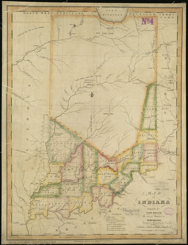
America Transformed: Indiana Territory ("Land of Indians") was similarly carved out of the Northwest Territory in 1800. Published in 1817, a year after Indiana’s statehood, this map indicates that officials had divided the southern third of the state into counties and townships. Numerous tribal nations, including the Myaamiaki (Miami), Kiikaapoi (Kickapoo), Lenape (Delaware), Shawnee, and Neshnabé (Potawatomi) inhabited the region. The map identifies land cessions before 1817 with dashed lines. From the 1820s through the 1840s these tribal communities were forcibly relocated, most often to reservations in the Great Plains or to Canada.
- Creator:
- Melish, John, 1771-1822
- Name on Item:
-
prepared by John Melish ; the surveys furnished by Burr Bradley.
- Date:
-
1817
- Format:
-
Maps/Atlases
- Location:
-
Boston Public Library
Norman B. Leventhal Map Center - Collection (local):
-
Norman B. Leventhal Map Center Collection
- Subjects:
-
Indiana--Maps
- Places:
-
Indiana
- Extent:
- 1 map : col. ; 45 x 34 cm.
- Terms of Use:
-
No known copyright restrictions.
No known restrictions on use.
- Publisher:
-
Philadelphia :
John Melish & Saml. Harrison
- Scale:
-
Scale 1:1,160,000.
- Language:
-
English
- Notes:
-
Relief shown pictorially.
Identifies counties in southern Indiana.
- Notes (exhibitions):
-
Exhibited: "America transformed. Part 1: the United States expands westward," organized by the Norman B. Leventhal Map & Education Center at the Boston Public Library, 2019.
- Identifier:
-
06_01_006294
- Call #:
-
G4090 1817 .M45
- Barcode:
-
39999059022200


