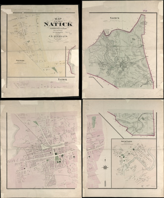
Map of the town of Natick Middlesex Co. Mass : from actual surveys
Item Information
- Title:
- Map of the town of Natick Middlesex Co. Mass : from actual surveys
- Creator:
- Tucker, F. C., civil engineer
- Name on Item:
-
by F.C. Tucker, C.E. ; printed by Charles Hart ; engraved by L.E. Newman.
- Date:
-
1874
- Format:
-
Maps/Atlases
- Location:
-
Boston Public Library
Norman B. Leventhal Map Center - Collection (local):
-
Norman B. Leventhal Map Center Collection
- Subjects:
-
Real property--Massachusetts--Natick--Maps
Landowners--Massachusetts--Natick--Maps
Natick (Mass.)--Maps
- Places:
-
Middlesex (county)Natick
- Extent:
- 1 map on 4 sheets : col. ; 125 x 114 cm., sheets 84 x 70 cm.
- Terms of Use:
-
No known copyright restrictions.
No known restrictions on use.
- Publisher:
-
New York :
J.B. Beers & Co.
- Scale:
-
Scale 1:12,000.
Scale 1:2,400.
- Language:
-
English
- Notes:
-
Relief shown by hachures.
Insets: Felchville, Natick (town center), and South natick.
Entered according to act of Congress A.D. 1874 by J.B. Beers & Co. in the office of the Librarian of Congress at Washington.
- Identifier:
-
06_01_005563
- Call #:
-
G3764.N2G46 1874 .T8x
- Barcode:
-
39999059015105