Course of canal to Charlestown Millpond
Item Information
- Title:
- Course of canal to Charlestown Millpond
- Description:
-
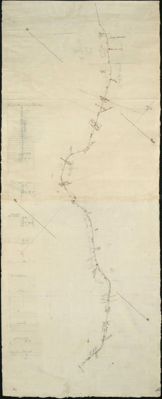
This manuscript survey describes the course of the final 2.25 miles of the Middlesex Canal, terminating in the Charlestown Millpond. Distances are marked off in rods, and property owners indicated, as are locks, culverts crossroads (e.g., the Great Boston Road), and other features. Columns of calculations at left tally lengths of canal on different property owners' land. (From Dealer's notes.)
- Contributor:
- Baldwin, Loammi, 1780-1838
- Date:
-
[ca. 1802]
- Format:
-
Maps/Atlases
Manuscripts
- Location:
-
Boston Public Library
Norman B. Leventhal Map Center - Collection (local):
-
Norman B. Leventhal Map Center Collection
- Subjects:
-
Landowners--Massachusetts--Middlesex Canal--Maps, Manuscript
Middlesex Canal (Mass.)--Maps, Manuscript
- Places:
-
Middlesex (county)Middlesex Canal
- Extent:
- 1 ms. map ; on sheet 81 x 33 cm.
- Terms of Use:
-
No known copyright restrictions.
No known restrictions on use.
- Scale:
-
Scale not given
- Language:
-
English
- Notes:
-
Title from verso.
Oriented with north toward the upper right.
- Identifier:
-
06_01_005504
- Call #:
-
G3762.M38 1802 .C6x
- Barcode:
-
39999059014975


