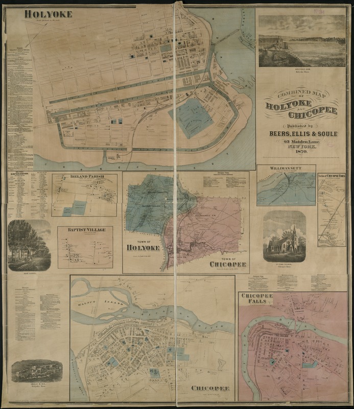
Combined map of Holyoke and Chicopee
Item Information
- Title:
- Combined map of Holyoke and Chicopee
- Date:
-
1870
- Format:
-
Maps/Atlases
- Location:
-
Boston Public Library
Norman B. Leventhal Map Center - Collection (local):
-
Norman B. Leventhal Map Center Collection
- Subjects:
-
Real property--Massachusetts--Holyoke--Maps
Landowners--Massachusetts--Holyoke--Maps
Real property--Massachusetts--Chicopee--Maps
Landowners--Massachusetts--Chicopee--Maps
Chicopee (Mass.)--Maps
Holyoke (Mass.)--Maps
- Places:
-
Hampden (county)Chicopee
Hampden (county)Holyoke
- Extent:
- 1 map : col. ; 116 x 100 cm.
- Terms of Use:
-
No known copyright restrictions.
No known restrictions on use.
- Publisher:
-
New York :
Beers, Ellis & Soule
- Scale:
-
Scales differ.
- Language:
-
English
- Notes:
-
Includes lists of businesses, landowners names, eight maps and four illustrations.
- Identifier:
-
06_01_005342
- Call #:
-
G3764.H7G46 1870 .C6x
- Barcode:
-
39999059015071