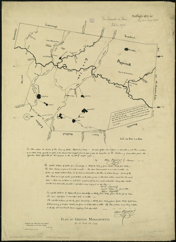
Plan of Groton, Massachusetts : as it was in 1794
Item Information
- Title:
- Plan of Groton, Massachusetts : as it was in 1794
- Creator:
- Prescott, Oliver.
- Name on Item:
-
by Oliver Prescott, Jnr., surveyor.
- Date:
-
1894
- Format:
-
Maps/Atlases
- Location:
-
Boston Public Library
Norman B. Leventhal Map Center - Collection (local):
-
Norman B. Leventhal Map Center Collection
- Subjects:
-
Manuscript maps--Early works to 1800--Facsimiles
Groton (Mass. : Town)--Maps, Manuscript--Early works to 1800--Facsimiles
Pepperell (Mass. : Town)--Maps, Manuscript--Early works to 1800--Facsimiles
Shirley (Mass. : Town)--Maps, Manuscript--Early works to 1800--Facsimiles
Massachusetts--Boundaries--Maps, Manuscript--Early works to 1800--Facsimiles
- Places:
-
Middlesex (county)Groton
Middlesex (county)Pepperell
Middlesex (county)Shirley
- Extent:
- 1 map ; 32 x 37 cm., on sheet 56 x 41 cm.
- Terms of Use:
-
No known copyright restrictions.
No known restrictions on use.
- Publisher:
-
Boston :
S.A. G[reen]
- Scale:
-
Scale [ca. 1:11,880]
- Language:
-
English
- Notes:
-
Shows boundaries of the towns of Groton, Pepperrell, and Shirley.
Facsim. of a ms. map.
"Jan. 15, 1894."
"Reduced one third from the original manuscript at the State House."
Oriented with north toward the upper right.
Includes text.
Reproduction of: This plan contains the bounds of three towns, viz. Groton, Pepperell & Shirley, [1794]. in the Massachusetts State House.
- Identifier:
-
06_01_005340
- Call #:
-
G3764.G86 1794 .P7 1894
- Barcode:
-
39999059013233


