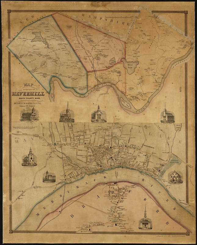
Map of the town of Haverhill, Essex County, Mass
Item Information
- Title:
- Map of the town of Haverhill, Essex County, Mass
- Creator:
- Walling, Henry Francis, 1825-1888
- Name on Item:
-
from surveys under the direction of Henry F. Walling.
- Date:
-
1851
- Format:
-
Maps/Atlases
- Location:
-
Boston Public Library
Norman B. Leventhal Map Center - Collection (local):
-
Norman B. Leventhal Map Center Collection
- Subjects:
-
Landowners--Massachusetts--Haverhill--Maps
Central business districts--Massachusetts--Haverhill--Maps
Haverhill (Mass.)--Maps
- Places:
-
Essex (county)Haverhill
- Extent:
- 1 map : col. ; 88 x 74 cm.
- Terms of Use:
-
No known copyright restrictions.
No known restrictions on use.
- Publisher:
-
[Massachusetts?] :
A.B. Jaques
- Scale:
-
Scale [ca. 1:19,900].
- Language:
-
English
- Notes:
-
Relief shown by hachures.
Shows names of landowners.
Includes ancillary map of downtown Haverhill and eight illustrations.
- Identifier:
-
06_01_005169
- Call #:
-
G3764.H5 1851 .W3
- Barcode:
-
39999059010080
- LCCN:
-
2004631170