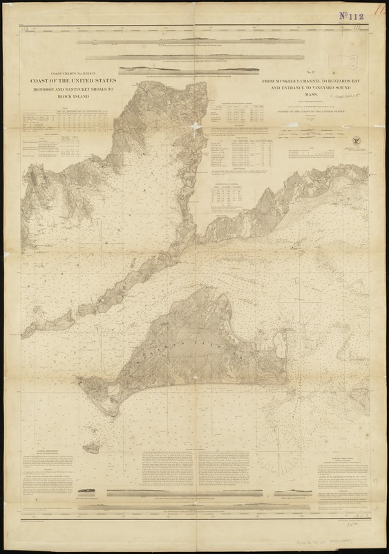
From Muskeget Channel to Buzzard's Bay and entrance to Vineyard Sound, Mass
Item Information
- Title:
- From Muskeget Channel to Buzzard's Bay and entrance to Vineyard Sound, Mass
- In upper left margin :
- Muskeget Channel to Buzzards Bay and entrance to Vineyard Sound, Mass
- Title (alt.) :
- Coast of the United States
- Title (alt.) :
- Monomoy and Nantucket Shoals to Block Island
- Creator:
- United States Coast Survey
- Name on Item:
-
from a trigonometrical survey under the direction of A.D. Bache, superintendent of the Survey of the Coast of the United States ; verified, W.R. Palmer.
- Date:
-
1860
- Format:
-
Maps/Atlases
- Location:
-
Boston Public Library
Norman B. Leventhal Map Center - Collection (local):
-
Norman B. Leventhal Map Center Collection
- Subjects:
-
Nautical charts--Massachusetts--Atlantic Coast
Nautical charts--Massachusetts--Buzzards Bay (Bay)
Nautical charts--Massachusetts--Vineyard Sound
Nautical charts--Massachusetts--Nantucket Sound
Coasts--Massachusetts--Maps
Atlantic Coast (Mass.)--Maps
Buzzards Bay (Mass. : Bay)--Maps
Vineyard Sound (Mass.)--Maps
Nantucket Sound (Mass.)--Maps
Martha's Vineyard (Mass.)--Maps
Elizabeth Islands (Mass.)--Maps
Massachusetts--Maps
- Places:
-
MassachusettsBuzzards Bay
MassachusettsDukes (county)Nantucket Sound (bay)
MassachusettsDukes (county)Elizabeth Islands (area)
Vineyard Sound
- Extent:
- 1 map ; 93 x 68 cm.
- Terms of Use:
-
No known copyright restrictions.
No known restrictions on use.
- Publisher:
-
[Washington, D.C.] :
U.S. Coast Survey Office
- Scale:
-
Scale 1:80,000
- Language:
-
English
- Notes:
-
Also covers Martha's Vineyard and the Elizabeth Islands.
Relief shown by shading and landform drawings. Depths shown by soundings and contours.
Triangulation, topography, and hydrography conducted between 1844 and 1857.
Includes 7 views of shorelines as seen from the ocean.
- Identifier:
-
06_01_005163
- Call #:
-
G3701.P5 svar .U5 no. 112 1890
- Barcode:
-
39999059009991


