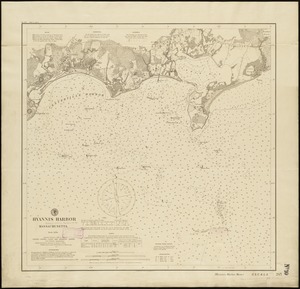
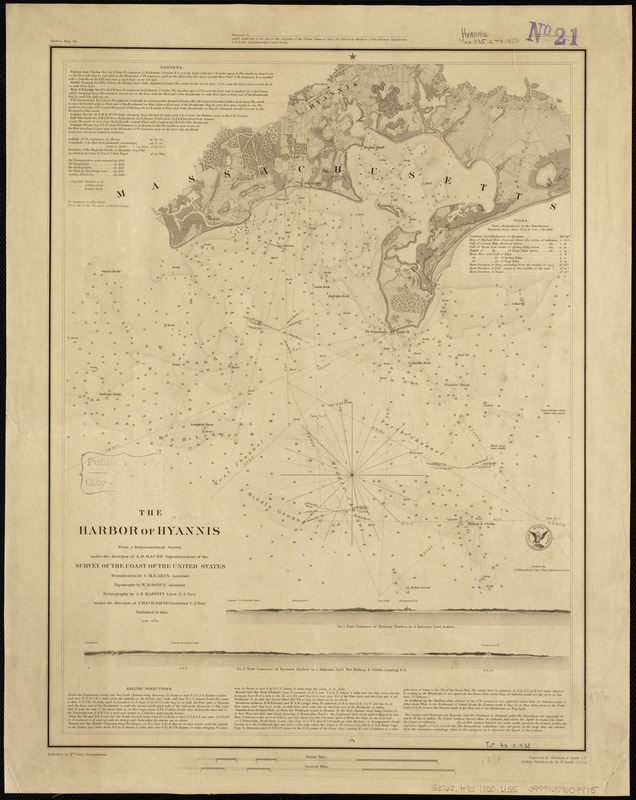
The harbor of Hyannis
Item Information
- Title:
- The harbor of Hyannis
- Creator:
- United States Coast Survey
- Name on Item:
-
from a trigonometrical survey under the direction of A.D. Bache, superintendent of the Survey of the Coast of the United States ; triangulation by C.M. Eakin ; topography by W.M. Boyce ; hydrography by J.N. Maffitt under the direction of Chas. H. Davis ; verified by A.A. Humphreys.
- Date:
-
1850
- Format:
-
Maps/Atlases
- Location:
-
Boston Public Library
Norman B. Leventhal Map Center - Collection (local):
-
Norman B. Leventhal Map Center Collection
- Subjects:
-
Nautical charts--Massachusetts--Hyannis Harbor
Harbors--Massachusetts--Hyannis--Maps
Hyannis Harbor (Mass.)--Maps
Hyannis (Mass.)--Maps
- Places:
-
Barnstable (county)Hyannis Harbor
Barnstable (county)Hyannis
- Extent:
- 1 map ; 45 x 34 cm.
- Terms of Use:
-
No known copyright restrictions.
No known restrictions on use.
- Publisher:
-
[Washington, D.C.] :
U.S. Coast Survey Office ; Sherman & Smith
- Scale:
-
Scale 1:30,000
- Language:
-
English
- Notes:
-
Relief shown by hachures. Depths shown by soundings and contours.
Includes tide information, sailing directions, notes and 2 views of entrances to the harbor as seen from the ocean.
- Identifier:
-
06_01_005161
- Call #:
-
G3762.H95 1850 .U55
- Barcode:
-
39999059009975