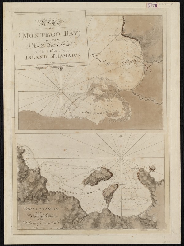
A chart of Montego Bay on the north west shore of the island of Jamaica : Port Antonio on the north east shore of the island of Jamaica
This map is also available in American Revolutionary Geographies Online (ARGO), a collections portal especially built for material relating to the American Revolutionary War Era. Visit ARGO to learn more about this item and explore the historical geography of North America in the late eighteenth century.
Item Information
- Title:
- A chart of Montego Bay on the north west shore of the island of Jamaica : Port Antonio on the north east shore of the island of Jamaica
- Title (alt.):
-
Port Antonio on the north east shore of the island of Jamaica
- Description:
-
The most profitable commodity produced in the colonies was sugar, and the plantations of Jamaica created a vast amount of wealth for British merchants. Jamaica became the center of the Caribbean sugar trade by the 18th century; however, unlike the mainland colonies, the island never became self-sufficient – it existed only for the production of the crop. This 1780 chart of Montego Bay and Port Antonio shows two areas of the island that were dedicated to the export of raw sugar. Safe navigation of these ports was essential to the continuation of the sugar trade, and Britain made a point to conduct hydrographic surveys of the area, as they did on the mainland.
- Creator:
- Des Barres, Joseph F. W. (Joseph Frederick Wallet), 1722-1824
- Date:
-
1780
- Format:
-
Maps/Atlases
- Location:
-
Boston Public Library
Norman B. Leventhal Map Center - Collection (local):
-
Norman B. Leventhal Map Center Collection
- Subjects:
-
Jamaica--Maps--Early works to 1800
Montego Bay (Jamaica)--Maps--Early works to 1800
Port Antonio (Jamaica)--Maps--Early works to 1800
- Places:
-
Jamaica
Cornwall (county)Montego Bay
Portland (county)Port Antonio
- Extent:
- 2 maps on 1 sheet ; 37 x 48 cm and 32 x 48 cm.
- Terms of Use:
-
No known copyright restrictions.
No known restrictions on use.
- Publisher:
-
[London] :
J.F.W. Des Barres
- Scale:
-
Scale [ca. 1:8,000]
Scale [ca. 1:18,000]
- Language:
-
English
- Notes:
-
Relief shown by shading and hachures. Depths shown by soundings.
Appears in the author's Atlantic Neptune. London : [J.F.W. Des Barres], 1777-[1781].
- Notes (exhibitions):
-
Exhibited: "Charting an Empire: The Atlantic Neptune" organized by the Norman B. Leventhal Map Center at the Boston Public Library, 2013.
- Identifier:
-
06_01_004998
- Call #:
-
G1106.P5 D47 1777
- Barcode:
-
30000003813690