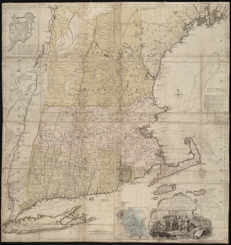
A map of the most inhabited part of New England : containing the provinces of Massachusets Bay and New Hampshire, with the colonies of Conecticut and Rhode Island, divided into counties and townships : the whole composed from actual surveys and its situation adjusted by astronomical observations
This map is also available in American Revolutionary Geographies Online (ARGO), a collections portal especially built for material relating to the American Revolutionary War Era. Visit ARGO to learn more about this item and explore the historical geography of North America in the late eighteenth century.
Item Information
- Title:
- A map of the most inhabited part of New England : containing the provinces of Massachusets Bay and New Hampshire, with the colonies of Conecticut and Rhode Island, divided into counties and townships : the whole composed from actual surveys and its situation adjusted by astronomical observations
- Description:
-
This large, detailed map of New England was compiled by Braddock Mead (alias John Green), and first published by Thomas Jefferys in 1755. Green was an Irish translator, geographer, and editor, as well as one of the most talented British map-makers at mid-century. The map was re-published at the outset of the American Revolution, as it remained the most accurate and detailed survey of New England. Of interest are engraved double lines found beneath certain place-names, including Boston. These lines indicate cities whose longitude had been calculated with the aid of the newly invented marine chronometer.
- Creator:
- Jefferys, Thomas, d. 1771
- Contributor:
- Green, John, d. 1757
- Date:
-
1774
- Format:
-
Maps/Atlases
- Location:
-
Boston Public Library
Norman B. Leventhal Map Center - Collection (local):
-
Norman B. Leventhal Map Center Collection
- Subjects:
-
New England--Maps--Early works to 1800
- Places:
-
New England (area)
- Extent:
- 1 map on 2 sheets : hand col. ; 104 x 98 cm.
- Terms of Use:
-
No known copyright restrictions.
No known restrictions on use.
- Publisher:
-
[London] :
Thos. Jefferys
- Scale:
-
Scale [ca. 1:440,000]
- Language:
-
English
- Notes:
-
4th state (LC).
3rd edition (Stevens & Tree).
Prime meridians: London and Ferro.
Relief shown pictorially.
Includes compilation data and insets of "A plan of the town of Boston" and "A plan of Boston Harbor from an accurate survey," ca. 1:150,000.
- Identifier:
-
06_01_004841
- Call #:
-
G3720 1774 .J44
- Barcode:
-
39999059003382


