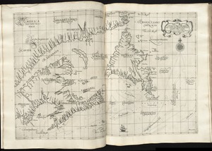
Chart of the Streights of Belle Isle
Item Information
- Title:
- Chart of the Streights of Belle Isle
- Title (alt.):
-
Bay of Fundy
- Publisher:
- Norman, John, 1748?-1817
- Date:
-
[1794]
- Format:
-
Maps/Atlases
- Location:
-
Boston Public Library
Norman B. Leventhal Map Center - Collection (local):
-
Norman B. Leventhal Map Center Collection
- Subjects:
-
Coasts--Newfoundland and Labrador--Maps--Early works to 1800
Coasts--Nova Scotia--Maps--Early works to 1800
Coasts--Québec (Province)--Maps--Early works to 1800
Nautical charts--Belle Isle, Strait of (N.L.)--Early works to 1800
Nautical charts--Saint Lawrence, Gulf of--Early works to 1800
Belle Isle, Strait of (N.L.)--Maps--Early works to 1800
Newfoundland and Labrador--Maps--Early works to 1800
Québec (Province)--Maps--Early works to 1800
Saint Lawrence, Gulf of--Maps--Early works to 1800
- Places:
-
CanadaBelle Isle, Strait of
CanadaSaint Lawrence, Gulf of
- Extent:
- 1 map ; 51 x 41 cm
- Terms of Use:
-
No known copyright restrictions.
No known restrictions on use.
- Publisher:
-
[Boston] :
[John Norman]
- Scale:
-
Scale approximately 1:1,120,000
- Language:
-
English
- Notes:
-
Title from Wheat & Brun.
Depths shown by soundings.
In Norman's American pilot. Boston : John Norman, 1794.
- Notes (date):
-
This date is inferred.
- Identifier:
-
06_01_004807
- Call #:
-
G1106.P5 N6 1794x
- Barcode:
-
30000005058364
![[Chart of the coast of Quebec from the Riviere St. Jean to Grand Hermine Bay]](https://bpldcassets.blob.core.windows.net/derivatives/images/commonwealth:7h149v50v/image_thumbnail_300.jpg)