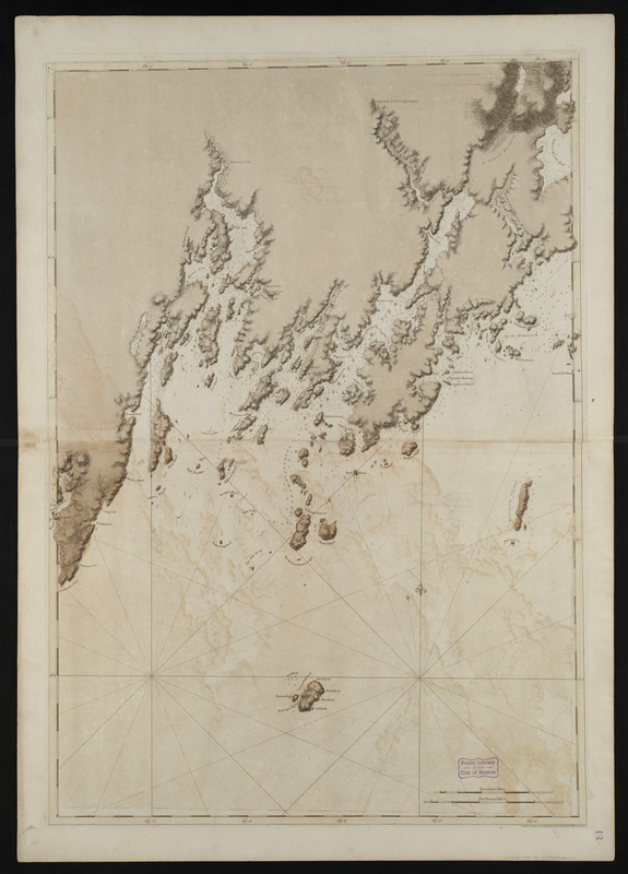
Coast of Maine from Rockland Harbor to Pemaquid Point
This map is also available in American Revolutionary Geographies Online (ARGO), a collections portal especially built for material relating to the American Revolutionary War Era. Visit ARGO to learn more about this item and explore the historical geography of North America in the late eighteenth century.
Item Information
- Title:
- Coast of Maine from Rockland Harbor to Pemaquid Point
- Creator:
- Des Barres, Joseph F. W. (Joseph Frederick Wallet), 1722-1824
- Date:
-
1776
- Format:
-
Maps/Atlases
- Location:
-
Boston Public Library
Norman B. Leventhal Map Center - Collection (local):
-
Norman B. Leventhal Map Center Collection
- Subjects:
-
Coasts--Maine--Knox County--Maps--Early works to 1800
Coasts--Maine--Lincoln County--Maps--Early works to 1800
Atlantic Coast (Me.)--Maps--Early works to 1800
Saint George River (Me.)--Maps--Early works to 1800
- Places:
-
Saint George River
Knox (county)
Lincoln (county)
- Extent:
- 1 chart : hand col. ; 106 x 75 cm.
- Terms of Use:
-
No known copyright restrictions.
No known restrictions on use.
- Publisher:
-
[London] :
J.F.W. Des Barres
- Edition:
- 4th state.
- Scale:
-
Scale [ca. 1:49,000]
- Language:
-
English
- Notes:
-
Title from published bibliography.
Relief shown by hachures. Depths shown by soundings.
Has watermark of "J Bates."
Shows the coast of Knox and Lincoln Counties.
Plat number "7" engraved in a small oval in the upper left corner.
From the author's Atlantic Neptune.
- Identifier:
-
06_01_004478
- Call #:
-
G1106.P5 D47 1781
- Barcode:
-
30000003813965


![[Coast of Maine from Frenchman Bay to Mosquito Harbor]](https://bpldcassets.blob.core.windows.net/derivatives/images/commonwealth:cj82m295n/image_thumbnail_300.jpg)

