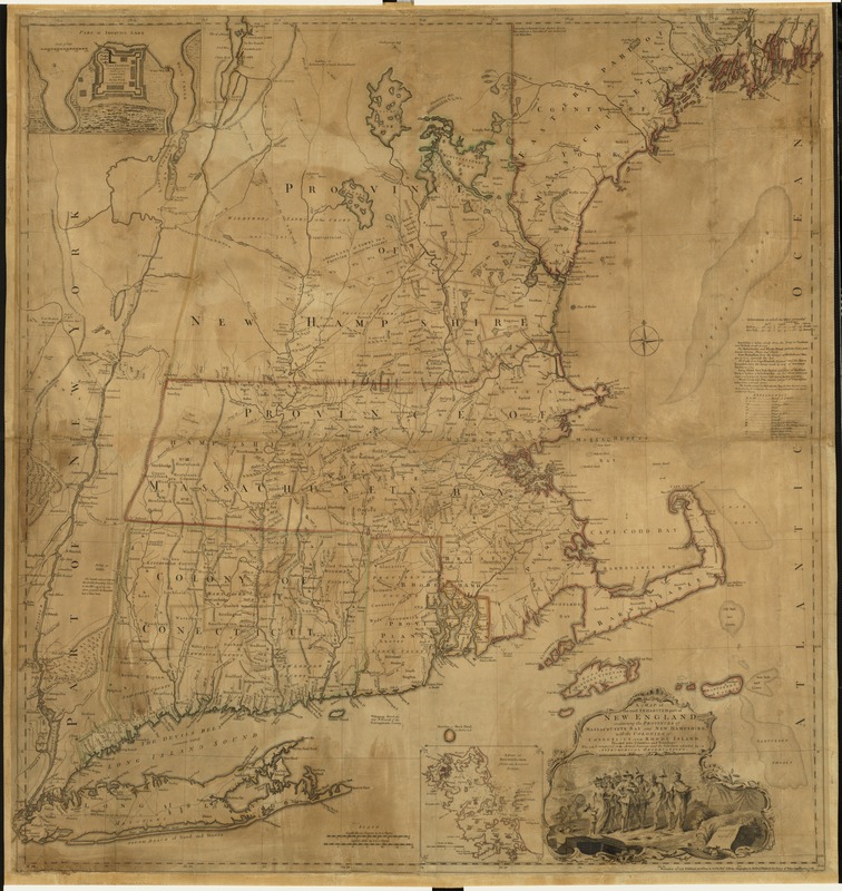
A map of the most inhabited part of New England : containing the provinces of Massachusets Bay and New Hampshire, with the colonies of Conecticut and Rhode Island, divided into counties and townships : the whole composed from actual surveys and its situation adjusted by astronomical observations
This map is also available in American Revolutionary Geographies Online (ARGO), a collections portal especially built for material relating to the American Revolutionary War Era. Visit ARGO to learn more about this item and explore the historical geography of North America in the late eighteenth century.
Item Information
- Title:
- A map of the most inhabited part of New England : containing the provinces of Massachusets Bay and New Hampshire, with the colonies of Conecticut and Rhode Island, divided into counties and townships : the whole composed from actual surveys and its situation adjusted by astronomical observations
- Description:
-
Boston mapmaking was influential in forming Great Britain's perception of the New England colonies. For example, though William Douglass made his map of New England for local consumption, London publisher Thomas Jefferys targeted the English market by adapting it to illustrate a larger struggle for empire. Using Douglass' map as his primary source, Jefferys made additions based on other colonial surveys and added an inset plan of Fort Saint Frederic, a French "incroachment" on Lake Champlain. This map went through several editions and for over 50 years was the pre-eminent map of New England.
- Creator:
- Jefferys, Thomas, d. 1771
- Date:
-
1755
- Format:
-
Maps/Atlases
- Location:
-
Boston Public Library
Norman B. Leventhal Map Center - Collection (local):
-
Norman B. Leventhal Map Center Collection
- Subjects:
-
United States--History--French and Indian War, 1754-1763--New England--Maps--Early works to 1800
New England--Maps--Early works to 1800
Boston Harbor (Mass.)--Maps--Early works to 1800
Fort Albany (N.Y.)--Maps--Early works to 1800
- Places:
-
CanadaFort Albany
New England (area)
Boston Harbor
Fort Frederick (historical)
- Extent:
- 1 map : hand col. ; 102 x 97 cm.
- Terms of Use:
-
No known copyright restrictions.
No known restrictions on use.
- Publisher:
-
[London] :
Thos. Jefferys
- Scale:
-
Scale [ca. 1:440,000]
- Language:
-
English
- Notes:
-
Prime meridians: London and Ferro.
Relief shown pictorially.
Insets: [Fort Frederik] [ca. 1:1,680] -- A plan of Boston Harbor from an accurate survey [ca. 1:150,000].
First edition, second issue with Connecticut spelled Conecticut. Alternate date 1759.
- Notes (exhibitions):
-
Exhibited: "Made in Boston" organized by the Norman B. Leventhal Map Center at the Boston Public Library, 2013-2014.
- Identifier:
-
06_01_004465
- Call #:
-
G3720 1755 .G7x
- Barcode:
-
39999059006716


