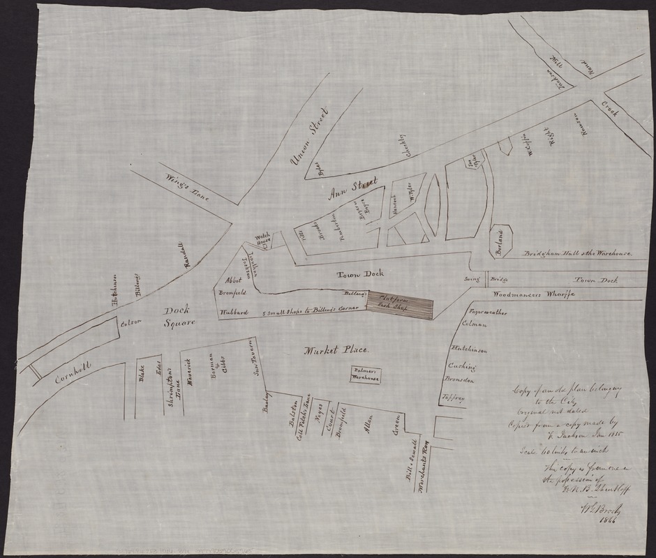
Copy of an old plan belonging to the city
Item Information
- Title:
- Copy of an old plan belonging to the city
- Creator:
- Brooks, W. G.
- Name on Item:
-
W.G. Brooks.
- Date:
-
1866
- Format:
-
Maps/Atlases
Manuscripts
- Location:
-
Boston Public Library
Norman B. Leventhal Map Center - Collection (local):
-
Norman B. Leventhal Map Center Collection
- Subjects:
-
Faneuil Hall (Boston, Mass.)--Maps, Manuscript
Boston (Mass.)--Maps, Manuscript
- Places:
-
Suffolk (county)Boston
Faneuil Hall
- Extent:
- 1 ms. plan. : on silk, 44 x 51 cm.
- Terms of Use:
-
No known copyright restrictions.
No known restrictions on use.
- Scale:
-
Scale [ca. 1:475].
- Language:
-
English
- Notes:
-
Shows the area of Dock Square, the Town Dock, and the market place, at the intersection of Wing's Lane, Union St., Ann St., and Cornhill. Now the Faneuil Hall marketplace area in Boston.
"Original not dated."
"Copied from a copy made by [L.] Jackson Jan. 1835."
"This copy is from one in the possession of Dr. N.B. Shurtleff."
- Identifier:
-
06_01_004310
- Call #:
-
G3764.B6:2F3 1866 .B7x
- Barcode:
-
39999059005965

![[Plan for proposed Charles River Park]](https://bpldcassets.blob.core.windows.net/derivatives/images/commonwealth:cf95jc91c/image_thumbnail_300.jpg)