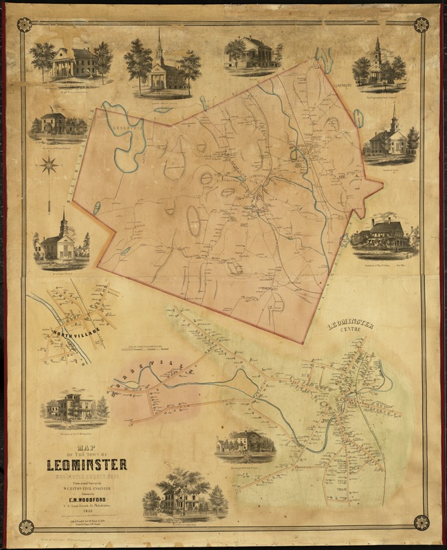
Map of the town of Leominster : Worcester County, Mass
Item Information
- Title:
- Map of the town of Leominster : Worcester County, Mass
- Creator:
- Eaton, W. C. (William C.)
- Name on Item:
-
from actual survey by W.C. Eaton.
- Date:
-
1855
- Format:
-
Maps/Atlases
- Location:
-
Boston Public Library
Norman B. Leventhal Map Center - Collection (local):
-
Norman B. Leventhal Map Center Collection
- Subjects:
-
Landowners--Massachusetts--Leominster--Maps
Leominster (Mass.)--Maps
- Places:
-
Worcester (county)Leominster
- Extent:
- 1 map : col. ; 116 x 92 cm.
- Terms of Use:
-
No known copyright restrictions.
No known restrictions on use.
- Publisher:
-
Philadelphia :
E.M. Woodford
- Scale:
-
Scale not given.
- Language:
-
English
- Notes:
-
Relief shown by hachures.
Includes eleven ill.
Details of Leominster centre, Morseville and North Village.
"Lith of Friend & Aub."
"Printed by Wagner & McGuigan."
- Identifier:
-
06_01_004168
- Call #:
-
G3764.L6 1855 .E2x
- Barcode:
-
39999059004638