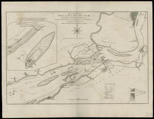
[Plan of engagement with British ships near Red Bank, New Jersey, October 22 and 23, 1777]
![[Plan of engagement with British ships near Red Bank, New Jersey, October 22 and 23, 1777]](https://bpldcassets.blob.core.windows.net/derivatives/images/commonwealth:9s161d76t/image_access_800.jpg)
Item Information
- Title:
- [Plan of engagement with British ships near Red Bank, New Jersey, October 22 and 23, 1777]
- Creator:
- Hazlewood, J.
- Date:
-
[1853]
- Format:
-
Maps/Atlases
- Location:
-
Boston Public Library
Norman B. Leventhal Map Center - Collection (local):
-
Norman B. Leventhal Map Center Collection
- Subjects:
-
Red Bank, Battle of, N.J., 1777--Maps
Red Bank (N.J.)--History--18th century--Maps
New Jersey--History--Revolution, 1775-1783--Maps
- Places:
-
Gloucester (county)Red Bank
- Extent:
- 1 plan ; on sheet 34 x 50 cm.
- Terms of Use:
-
No known copyright restrictions.
No known restrictions on use.
- Publisher:
-
Philadelphia :
s.n.
- Scale:
-
Scale not given.
- Language:
-
English
- Notes:
-
Facsimile.
Title supplied by cataloger.
"Accompanying Come. Hazelwood's letter, Decr. 9th 1779."
"No. 4 in upper left corner."
- Notes (date):
-
This date is inferred.
- Identifier:
-
06_01_003779
- Call #:
-
G3811.S3 1777 .H39 1853
- Barcode:
-
39999059002079