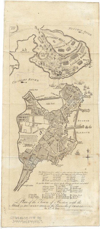
Plan of the town of Boston with the attack on Bunkers-Hill in the peninsula of Charlestown the 17th of June 1775
This map is also available in American Revolutionary Geographies Online (ARGO), a collections portal especially built for material relating to the American Revolutionary War Era. Visit ARGO to learn more about this item and explore the historical geography of North America in the late eighteenth century.
Item Information
- Title:
- Plan of the town of Boston with the attack on Bunkers-Hill in the peninsula of Charlestown the 17th of June 1775
- Date:
-
[1778]
- Format:
-
Maps/Atlases
- Location:
-
Boston Public Library
Norman B. Leventhal Map Center - Collection (local):
-
Norman B. Leventhal Map Center Collection
- Subjects:
-
Bunker Hill, Battle of, Boston, Mass., 1775--Maps--Early works to 1800
Boston (Mass.)--History--Revolution, 1775-1783--Maps--Early works to 1800
Charlestown (Boston, Mass.)--History--Maps--Early works to 1800
United States--History--Revolution, 1775-1783--Maps
- Places:
-
Suffolk (county)BostonBunker Hill
Suffolk (county)BostonCharlestown
- Extent:
- 1 map ; 29 x 14 cm.
- Terms of Use:
-
No known copyright restrictions.
No known restrictions on use.
- Publisher:
-
Newcastle Upon Tyne :
T. Robson
- Scale:
-
Scale ca. 1:19,300.
- Language:
-
English
- Notes:
-
Relief shown pictorially and by hachures.
Appears in the English edition of James Murray's An impartial history of the present war in America (Newcastle upon Tyne: T. Robson, [1778-80]) [4416.7.1].
Charlestown shown in flames.
Table of references identifies important streets and buildings and gives dates of fires that damaged the town.
- Notes (date):
-
This date is inferred.
- Identifier:
-
06_01_003104
- Call #:
-
G3764.B6S3 1778 .P5
- Barcode:
-
39999058998459


