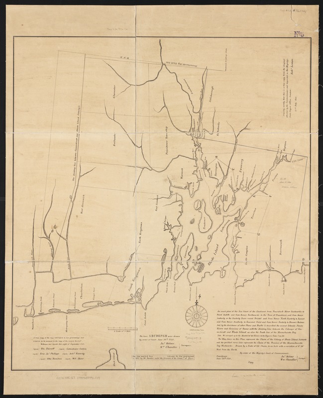
An exact plan of the sea coast of the continent from Paucatuck River eastwards to Point Judith and from thence northwards to the town of Providence and from thence southerly or the easterly shore round Bristol and from thence north easterly to assonet and from thence southerly to Seaconet Point and from thence easterly to Slocum's Harbour : and by the assistance of other plans and drafts is described the several islands ponds rivers and divisions of towns with the dividing line between the colonys of Connecticutt and Rhode Island as also the south line of the Massachusetts Bay
Item Information
- Title:
- An exact plan of the sea coast of the continent from Paucatuck River eastwards to Point Judith and from thence northwards to the town of Providence and from thence southerly or the easterly shore round Bristol and from thence north easterly to assonet and from thence southerly to Seaconet Point and from thence easterly to Slocum's Harbour : and by the assistance of other plans and drafts is described the several islands ponds rivers and divisions of towns with the dividing line between the colonys of Connecticutt and Rhode Island as also the south line of the Massachusetts Bay
- Name on Item:
-
Jas. Helme, Wm. Chandler surveyors.
- Date:
-
[1845]
- Format:
-
Maps/Atlases
- Location:
-
Boston Public Library
Norman B. Leventhal Map Center - Collection (local):
-
Norman B. Leventhal Map Center Collection
- Subjects:
-
Rhode Island--Maps--Early works to 1800--Facsimiles
- Places:
-
Rhode Island
- Extent:
- 1 plan ; 78 x 70 cm.
- Terms of Use:
-
No known copyright restrictions.
No known restrictions on use.
- Publisher:
-
London :
s.n.
- Scale:
-
Scale [ca. 1:120,400]
- Language:
-
English
- Notes:
-
Facsimile.
Oriented with north toward the upper right.
Relief shown by hachures.
"I hereby certify that this is a true copy from the original attested by the Commissioners and deposited in Her Majesty's State Paper Office, London." Signed Robt. Lemon, 22nd July, 1845.
Original version: Providence, 1741.
- Notes (date):
-
This date is inferred.
- Identifier:
-
06_01_002625
- Call #:
-
G3770 1741 .G7 1845x
- Barcode:
-
39999058996339


