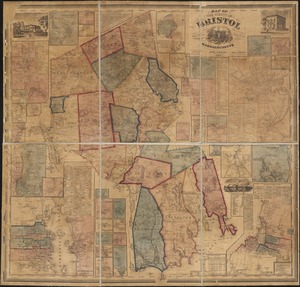
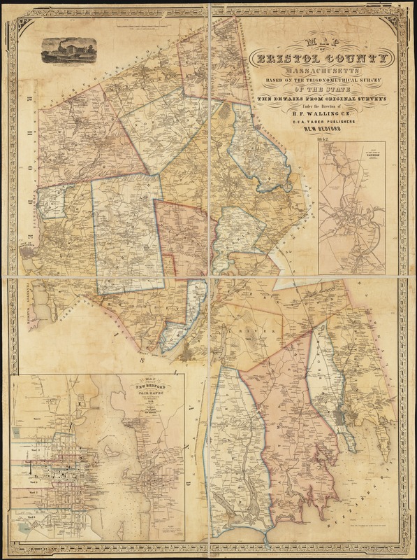
Map of Bristol County Massachusetts : based on the trigonometrical survey of the state
Item Information
- Title:
- Map of Bristol County Massachusetts : based on the trigonometrical survey of the state
- Title (alt.):
-
Map of the city of New Bedford and the village of Fair Haven
- Creator:
- Walling, Henry Francis, 1825-1888
- Name on Item:
-
the details from original surveys under the direction of H.F. Walling.
- Date:
-
1852
- Format:
-
Maps/Atlases
- Location:
-
Boston Public Library
Norman B. Leventhal Map Center - Collection (local):
-
Norman B. Leventhal Map Center Collection
- Subjects:
-
Bristol County (Mass.)--Maps
Taunton (Mass.)--Maps
New Bedford (Mass.)--Maps
- Places:
-
Bristol (county)Taunton
Bristol (county)New Bedford
- Extent:
- 1 map : col. ; 130 x 95 cm.
- Terms of Use:
-
No known copyright restrictions.
No known restrictions on use.
- Publisher:
-
New Bedford (Mass.) :
C. & A. Taber
- Scale:
-
Scale 1:50,688.
- Language:
-
English
- Notes:
-
Relief shown by hachures.
Includes insets: Map of the town of Taunton and Map of the city of New Bedford and the village of Fair Haven, from actual survey by H.F. Walling. New Bedford : C. & A. Taber, 1851.
Includes vignette of Whittenton Mills, Taunton.
- Identifier:
-
06_01_002623
- Call #:
-
G3763.B7 1852 .W3
- Barcode:
-
39999058996313