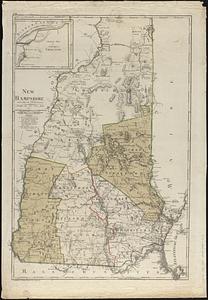
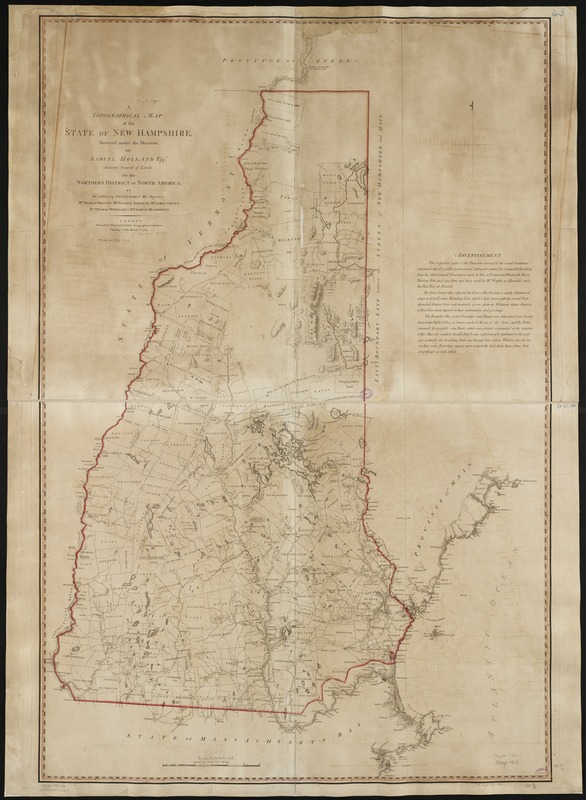
A topographical map of the state of New Hampshire
This map is also available in American Revolutionary Geographies Online (ARGO), a collections portal especially built for material relating to the American Revolutionary War Era. Visit ARGO to learn more about this item and explore the historical geography of North America in the late eighteenth century.
Item Information
- Title:
- A topographical map of the state of New Hampshire
- Description:
-
This rare map of New Hampshire was prepared from surveys by Samuel Holland - famed engineer who entered British service during the French and Indian War (1754-1763). The map depicts New Hampshire in great detail, illustrating rivers, streams, lakes, elevations, township boundaries, roads, and structures. Two great arcs delineate the boundary of a parcel known as "Mason's Curve." The parcel, owned by John Mason (1586-1635), was originally located between the Merrimack and Kennebeck Rivers, however in 1748 was sold by one of Mason's descendants to twelve investors from Portsmouth. It is believed these investors commissioned the surveys in 1768-69 to more accurately locate the boundary of the landholding.
- Creator:
- Holland, Samuel, 1728-1801
- Name on Item:
-
surveyed under the direction of Samuel Holland Esqr. surveyor general of lands for the northern district of North America, by the following gentelmen his deputies, Mr. Thomas Wright ...
- Date:
-
1784
- Format:
-
Maps/Atlases
- Location:
-
Boston Public Library
Norman B. Leventhal Map Center - Collection (local):
-
Norman B. Leventhal Map Center Collection
- Subjects:
-
New Hampshire--Maps--Early works to 1800
- Places:
-
New Hampshire
- Extent:
- 1 map : col. ; 117 x 77 cm.
- Terms of Use:
-
No known copyright restrictions.
No known restrictions on use.
- Publisher:
-
London :
Printed for William Faden
- Scale:
-
Scale ca. 1:260,000.
- Language:
-
English
- Notes:
-
Relief shown by hachures.
"Longitude of Portsmouth West from Greenwich Observatory."
- Identifier:
-
06_01_001847
- Call #:
-
G3740 1784 .H6
- Barcode:
-
39999058993724