City of Malden : 1881
Item Information
- Title:
- City of Malden : 1881
- Description:
-
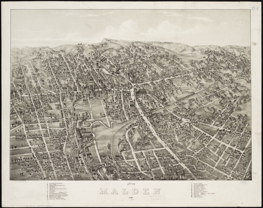
This view was probably commissioned to celebrate Malden's incorporation as a city in 1881. Not only was the drawing entitled City of Malden, but City Hall was identified as number one in the legend and was positioned almost at the center of the drawing. Not the most prominent building in the drawing, City Hall is yet easily spotted at the convergence of the five most prominent streets the northern and southern sections of Main Street with Pleasant, Salem, and Ferry Streets. The city is viewed from the south, looking north along the Malden River toward a prominent elevation (Wiatt's Hill) on the horizon. With a population of more than 12,000 at the time, the city was both an industrial center and a residential suburb. The legend identifies twenty-eight structures including six factories. The three largest, that manufactured rubber shoes, sand and emery paper, and leather goods, were located in the left foreground next to the river and between the two rail lines, one heading north and the other veering off to the northeast. The legend also identifies nine churches, four schools, a post office, a public library, and seven railroad stations on the two rail lines. Together with a horse-drawn street car line running along Main and Pleasant Streets, these structures give proof of the city's identity as a residential suburb.
- Creator:
- Downs, A. E. (Albert E.)
- Date:
-
1881
- Format:
-
Maps/Atlases
- Location:
-
Boston Public Library
Norman B. Leventhal Map Center - Collection (local):
-
Norman B. Leventhal Map Center Collection
- Subjects:
-
Malden (Mass.)--Aerial views
- Places:
-
Middlesex (county)Malden
- Extent:
- 1 view : col. ; 47 x 66 cm.
- Terms of Use:
-
No known copyright restrictions.
No known restrictions on use.
- Publisher:
-
Boston :
O.H. Bailey & Co.
- Scale:
-
Not drawn to scale.
- Language:
-
English
- Notes:
-
Bird's-eye view.
Indexed for points of reference.
- Notes (exhibitions):
-
Exhibited: "Boston & Beyond: A Bird’s Eye View of New England" organized by the Norman B. Leventhal Map Center at the Boston Public Library, 2008.
- Identifier:
-
06_01_001828
- Call #:
-
G3764.M2A3 1881 .D6
- Barcode:
-
39999058989979