City of Gloucester, Mass
Item Information
- Title:
- City of Gloucester, Mass
- Description:
-
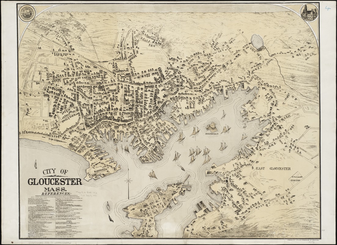
Gloucester was established as a town in 1642. By the middle of the 18th century it was an important ship building center, especially known for its schooners. It also developed a major fishing industry, as the town's fishermen exploited the resources of the Grand Banks off the coast of Nova Scotia and Newfoundland. These activities continued to be important throughout the 19th century. Viewed from a conventional cartographic perspective with north at the top of the sheet, this late 19th century drawing is dominated by Gloucester's superb natural harbor. Not only are there many vessels (primarily schooners) in the harbor, the water fronts of Gloucester, East Gloucester, and Rocky Neck villages are lined with wharves and buildings attesting to the communitys maritime economy. There is no evidence of heavy industrial activity. Although the list of business references in the lower left corner is not keyed to individual buildings in the drawing, it is clear that, outside of typical urban services (retail merchants, doctors, lawyers, insurance agents), most of the businesses pertain to maritime activities. There is one manufacture of boats of all kinds, a ship chandler, a firm dealing in nets, seines, twine, and fish netting, and eight firms processing or selling fish. One of these, John Pew and Sons, became the town's most famous seafood business, eventually known as the Gorton-Pew Fisheries and today, Gortons of Gloucester. Although this view is undated, it was published some time after Gloucester was incorporated as a city in 1873, as indicated in the city seal reproduced in the upper left corner. The seal emphasizes the citys reliance on maritime activities by depicting a ship and a light house. The view was published by the Franklin Lithograph Company which is known to have been active from 1878-1880.
- Name on Item:
-
Franklin Lith.
- Date:
-
[1873?]
- Format:
-
Maps/Atlases
- Location:
-
Boston Public Library
Norman B. Leventhal Map Center - Collection (local):
-
Norman B. Leventhal Map Center Collection
- Subjects:
-
Gloucester (Mass.)--Aerial views
- Places:
-
Essex (county)Gloucester
- Extent:
- 1 view : col. ; 59 x 76 cm.
- Terms of Use:
-
No known copyright restrictions.
No known restrictions on use.
- Publisher:
-
Boston :
Franklin Lith.
- Scale:
-
Not drawn to scale.
- Language:
-
English
- Notes:
-
Bird's-eye view.
Indexed for points of reference.
- Notes (exhibitions):
-
Exhibited: "Boston & Beyond: A Bird’s Eye View of New England" organized by the Norman B. Leventhal Map Center at the Boston Public Library, 2008.
- Identifier:
-
06_01_002140
- Call #:
-
G3764.G4A3 1873 .C5
- Barcode:
-
39999058989961


