Map of the city of Boston and immediate neighborhood : from original surveys
Item Information
- Title:
- Map of the city of Boston and immediate neighborhood : from original surveys
- Description:
-
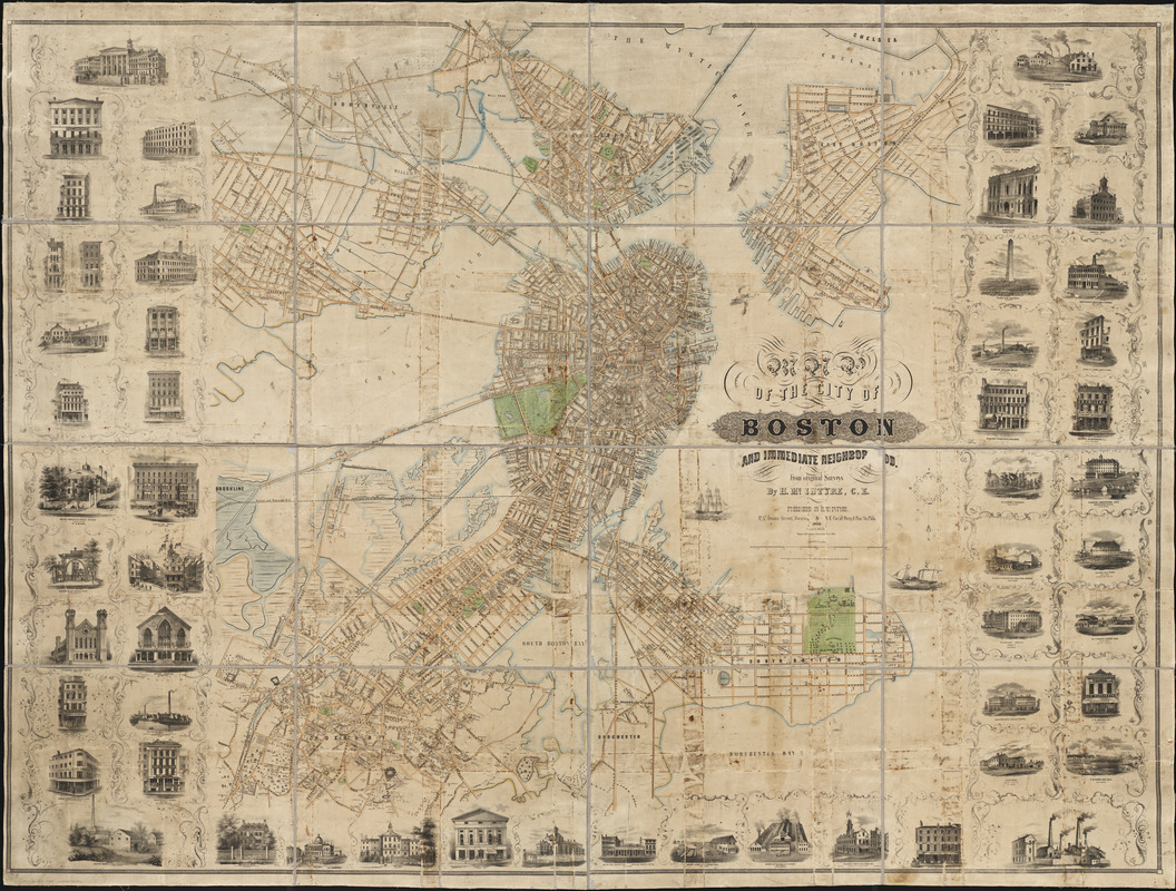
This large wall map provides a point of comparison for appreciating the various geographical perspectives used in the Boston birds eye views. It also serves as a baseline from which to trace the growth of Shawmut Peninsulas land mass during the last half of the 19th century when these views were published. It is plain that in 1852 the reclamation of Back Bay has not yet begun. Like most conventional maps, it is oriented with north at the top. However, unlike most city street maps, it also attempts to convey a visual image of the citys built environment by delineating the footprint or outline of individual buildings within the city. Combined with the 55 marginal vignettes showcasing selected public, commercial, and industrial structures, this map represents a transition between the standard city map and the birds eye view which was starting to emerge as a distinct genre. This map, which was the largest single-sheet map published of the city by the middle of the 19th century, shows in great detail the extent of urban development in Boston proper and in the areas surrounding its busy harbor. Not only were wharves and streets delineated and named in the city itself, they were also included for the neighboring communities of Cambridge, East Cambridge, Somerville, Charlestown, East Boston, South Boston, Dorchester, and Roxbury. All but the first three communities would eventually be incorporated into the City of Boston. By emphasizing individual structures, the map provides ample evidence of the citys prosperity. Boston appears in the 1850 census as the third largest city in the United States with a population of almost 137,000. Only New York City and Baltimore were larger. The neighboring communities of Roxbury, Charlestown, and Cambridge, with populations of 18,000, 17,000, and 15,000 respectively, also ranked among the nations 50 largest cities.
- Creator:
- McIntyre, H. (Henry)
- Contributor:
- Friend & Aub
- Contributor:
- Wagner & M'Guigan
- Name on Item:
-
by H. Mc Intyre
- Date:
-
1852
- Format:
-
Maps/Atlases
- Location:
-
Boston Public Library
Norman B. Leventhal Map Center - Collection (local):
-
Norman B. Leventhal Map Center Collection
- Subjects:
-
Boston (Mass.)--Maps
Boston (Mass.)--Buildings, structures, etc.
- Places:
-
MassachusettsSuffolk (county)Boston
- Extent:
- 1 map on 16 sheets : col. ; 142 x 192 cm.
- Terms of Use:
-
No known copyright restrictions.
No known restrictions on use.
- Publisher:
-
Boston :
H. McIntyre
- Scale:
-
Scale [1:5,400]
- Language:
-
English
- Notes:
-
Friend & Aub lith.
"Wagner & McGuigan's Steam Lith Press, Phila."
Fifty six views of buildings in left, right and bottom borders. Buildings depicted: Merchants Exchange -- A. & A. Lawrence & Co. -- Thacher, Shaw & Co. -- Birthplace of Franklin -- Bay State Glass Co. Works -- Bank of North America, Harnden & Co. -- Bank of Commerce, Commercial Mutual Marine Ins. Office -- Suffolk County Steam Flour Mills -- Boston & Lowell R.R. Station -- Redding & Co's. Tea Store -- T. Gilbert & Co. Piano Forte Manufactory -- Hallet Davis & Co. Piano-Forte Makers -- Mount Washington Female Seminary -- American House -- Richard Barry's Marble Works -- Old State House -- Fitchburg Rail Road Station -- Howard Atheneum -- Petridge & Co. -- New England Glass Co's Works -- Lyman Towle & Co -- Thayer, Hovey & Homer -- Roxbury Chemical Color Manufacturing Co. Works --
Hancock House -- State House -- City Hall -- Tremont Temple -- New Jail -- Boston Post Printing Office, Evening Gazette Office -- Henry Jones & Co's. Lumber Yard -- South Boston Iron Co's. Foundry -- Western View of Old State House -- Boston Locomotive Works -- Boston Museum -- Custom House -- Boston Athenaeum -- Faneuil Hall -- Bunker Hill Monument -- East Boston Iron & Gas Co. Works -- Glendon Rolling Mills -- Saroni & Co -- Evening Transcript Building -- Chilson, Richardson & Co. -- Dr. S.G. Howe's residence -- Perkins Institution and Mass. Asylum for the Blind --Boston & Worcester Rail Road Station -- Suffolk Lead Works -- Tremont House -- Mr. J.P. Monk's Lumber Yard -- Massachusetts General Hospital -- G.W. Warren & Co. -- Globe Works -- E.H. Briggs' Ship Yard -- Brooks Furniture Rooms -- American Flint Glass Works.
- Notes (exhibitions):
-
Exhibited: "Breathing Room: Mapping Boston's Green Spaces" organized by the Norman B. Leventhal Map & Center at the Boston Public Library, 2018.
- Identifier:
-
06_01_001701
- Call #:
-
G3764.B6 1852 .M35
- Barcode:
-
39999058989904


