Boston Highlands, Massachusetts : Wards 19, 20, 21 & 22 of Boston
Item Information
- Title:
- Boston Highlands, Massachusetts : Wards 19, 20, 21 & 22 of Boston
- Description:
-
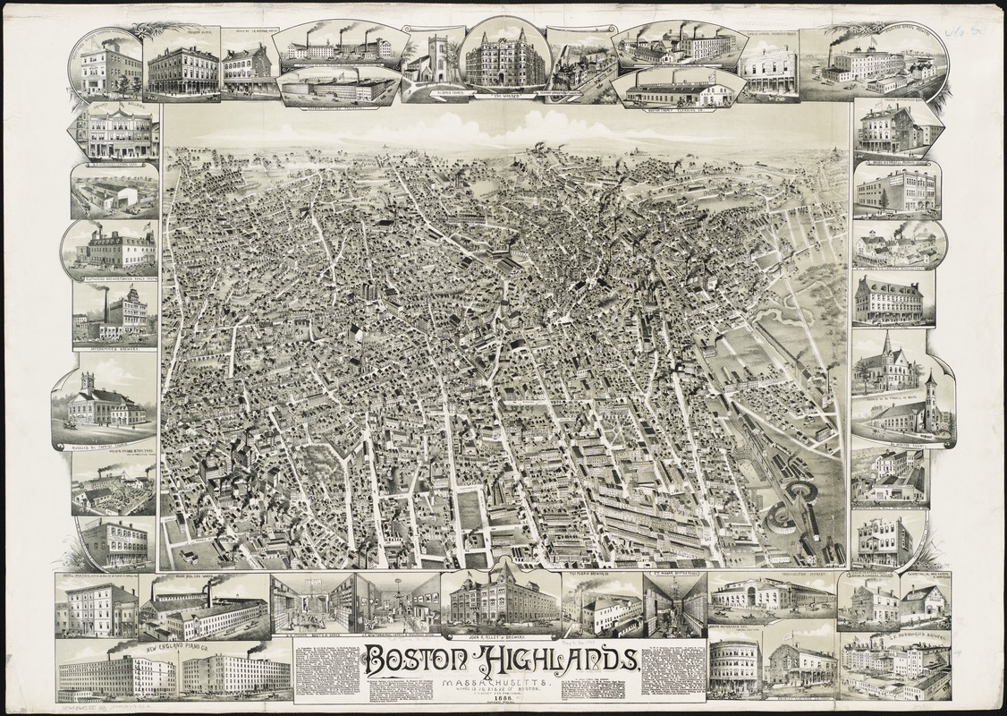
While most bird's eye views of Boston depict the central city, this view looks toward the southwest, as if the artist was positioned above Washington and Shawmut Streets at the base of the original peninsula. Entitled Boston Highlands, it encompasses much of Roxbury, looking out toward Grove Hall, Franklin Park and Jamaica Plain. Often left out of 19th century maps and views of Boston, Roxbury was essentially Bostons backdoor. It served as the landward entrance to Boston and was especially important during the American Revolution. From a military perspective, it commanded the entrance to the narrow peninsula that connected British-occupied Boston to the mainland, which the colonists held. During the first half of the19th century Roxbury developed into a suburban community overtaking a rural, agricultural township that was established in 1630, at the same time that Boston was founded. Roxbury was incorporated as a city in 1846 and was annexed as part of Boston in 1868. With continued urban growth and the filling in of land on either side of the peninsula's narrow neck, Roxbury became an integral part of Boston during the last half of the 19th century. As depicted here, Roxbury exemplifies the classical late-19th-century streetcar suburb. In fact, several horse-drawn street cars are visible on Harrison, Washington, Shawmut, and Tremont Streets leading into the city. An unsegregated mixture of various types of residential structures, churches, schools, commercial buildings, factories, and railroad facilities dominate the foreground and central portions of the drawing. The legend and forty marginal illustrations provide a virtual business directory for the community. They list and depict approximately 110 establishments. Among the factories, there are thirteen breweries as well as three cordage manufacturers, two carriage works, and single factories specializing in nails, pianos, crackers, lead, carpet, beltings, knives, and watches and clocks. Although twelve churches are listed or depicted, there are some that are not identified. Also unlabeled is the Boston Baseball Grounds in the lower right hand corner adjacent to the railroad round houses.
- Creator:
- O.H. Bailey & Co
- Date:
-
[1888]
- Format:
-
Maps/Atlases
- Location:
-
Boston Public Library
Norman B. Leventhal Map Center - Collection (local):
-
Norman B. Leventhal Map Center Collection
- Subjects:
-
Boston (Mass.)--Aerial views
- Places:
-
Suffolk (county)Boston
- Extent:
- 1 view : col. ; 74 x 97 cm.
- Terms of Use:
-
No known copyright restrictions.
No known restrictions on use.
- Publisher:
-
[S.l.] :
O.H. Bailey & Co.
- Scale:
-
Not drawn to scale.
- Language:
-
English
- Notes:
-
Bird's-eye view.
Includes index to points of interest and ill.
- Notes (date):
-
This date is inferred.
- Notes (exhibitions):
-
Exhibited: "Boston & Beyond: A Bird’s Eye View of New England" organized by the Norman B. Leventhal Map Center at the Boston Public Library, 2008.
- Identifier:
-
06_01_001571
- Call #:
-
G3764.B6A3 1888 .O43
- Barcode:
-
39999058989532
- LCCN:
-
75694562


