Plan of Boston
Item Information
- Title:
- Plan of Boston
- Description:
-
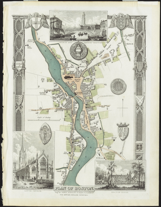
Boston, England, is depicted on this charming map, which appeared in an English county atlas published during the first half of the 19th century. The map is lightly colored with a decorative border. It also includes three inset illustrations of Church and Bridge Boston, Louth Church, and Nocton House. This English city is located on the Witham River in Lincolnshire. The river, which runs through the town, is bordered on the southeast by the South End, on the northeast by St. Botolph's Church and a market place, and on the west by High Street, all of which are names that are familiar in Boston, Massachusetts.
- Creator:
- Moule, Thomas, 1784-1851
- Cartographer:
- Moule, Thomas, 1784-1851
- Engraver:
- Bingley, James
- Publisher:
- Virtue, George, 1793?-1868
- Name on Item:
-
engd. by James Bingley, 57, Charles St. Goswell Rd. for Moule's English counties
- Date:
-
[1837]
- Format:
-
Maps/Atlases
- Location:
- Private Collection
- Collection (local):
-
Mapping Boston Collection
- Subjects:
-
Boston (England)--Maps
- Places:
-
EnglandLincolnshire (county)Boston
- Extent:
- 1 map : color ; 23 x 15 cm
- Terms of Use:
-
No known copyright restrictions.
This work is licensed for use under a Creative Commons Attribution Non-Commercial Share Alike License (CC BY-NC-SA).

- Publisher:
-
[London] :
[G. Virtue]
- Scale:
-
Scale approximately 1:1,437
- Language:
-
English
- Notes:
-
Appears in Moule's The English counties delineated. London: G Virtue, 1837.
Includes illustrations of seals and heraldic arms.
Includes 3 views: Church and Bridge Boston -- Louth Church -- Nocton House.
- Notes (date):
-
This date is inferred.
- Identifier:
-
06_01_001178
- Barcode:
-
39999052508726


