A chart of the sea coast of New Foundland, New Scotland, New England, New York, New Jersey, with Virginia and Maryland
Item Information
- Title:
- A chart of the sea coast of New Foundland, New Scotland, New England, New York, New Jersey, with Virginia and Maryland
- Description:
-
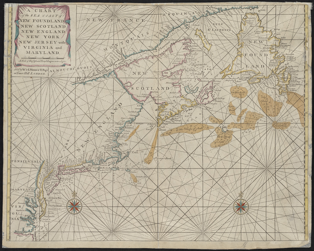
First published in 1689, John Thornton's chart of the north Atlantic seacoast illustrates the type of nautical charts available to navigators in the Fourth Book of the English Pilot, which was the standard resource for mariners at the time. The charts were flawed with numerous inaccuracies, and did not provide enough detail to have been truly beneficial to those sailing close to the shore. Many ships were damaged off the coasts of Newfoundland and Nova Scotia because accurate and comprehensive charts of the area were not available to those navigating to Canada from England. Featured here is state one from plate II. This new plate contains mainly bibliographical changes. This example is rare for its contemporary color, unusual in the English Pilot series. The chart showed all English ports in the Northeast, including Boston, Charlestown, and Dorchester.
- Creator:
- Thornton, John, 1641-1708
- Date:
-
[1713]
- Format:
-
Maps/Atlases
- Location:
- Private Collection
- Collection (local):
-
Mapping Boston Collection
- Subjects:
-
Nautical charts--Atlantic Coast (U.S.)--Early works to 1800
Nautical charts--Maritime Provinces--Early works to 1800
Maritime Provinces--Maps--Early works to 1800
Northeastern States--Maps--Early works to 1800
Middle Atlantic States--Maps--Early works to 1800
- Places:
-
Middle Atlantic (area)
Northeastern United States (area)
CanadaProvince of Prince Edward Island (province)
- Extent:
- 1 map : col. ; 46 x 58 cm.
- Terms of Use:
-
No known copyright restrictions.
This work is licensed for use under a Creative Commons Attribution Non-Commercial Share Alike License (CC BY-NC-SA).

- Publisher:
-
London :
Sold by W. & I. Mount & T. Page
- Scale:
-
Scale not given
- Language:
-
English
- Notes:
-
Depths shown by soundings.
- Notes (date):
-
This date is inferred.
- Notes (exhibitions):
-
Exhibited: "Charting an Empire: The Atlantic Neptune" organized by the Norman B. Leventhal Map Center at the Boston Public Library, 2013.
- Identifier:
-
06_01_001226
- Barcode:
-
39999052508536


