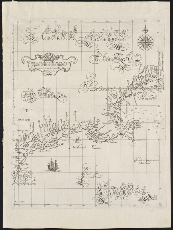
Carta particolare della Nuoua Belgia è parte della Nuoua Anglia
Item Information
- Title:
- Carta particolare della Nuoua Belgia è parte della Nuoua Anglia
- Title (alt.):
-
Carta particolare della Nuova Belgia è parte della Nuova Anglia
- Description:
-
Compiled by an Englishman but published in Italy, this was the earliest printed sailing chart showing New England. It appeared in Dudley's marine atlas, which was the first such atlas made of charts drawn on the Mercator projection. Many of the charts also identified prevailing winds, currents, soundings, and magnetic declination. Dudley, son of the Earl of Leicester and brother-in-law to Henry Cavendish the navigator, was exiled from England at a young age for his pretensions to the royal line. He spent most of his adult life in the learned city of Florence.
- Creator:
- Dudley, Robert, Sir, 1574-1649
- Date:
-
1661
- Format:
-
Maps/Atlases
- Location:
- Private Collection
- Collection (local):
-
Mapping Boston Collection
- Subjects:
-
New England--Maps--Early works to 1800--Facsimiles
New York (State)--Maps--Early works to 1800--Facsimiles
- Places:
-
New England (area)
New York
- Extent:
- 1 map ; 46 x 37 cm.
- Terms of Use:
-
No known copyright restrictions.
This work is licensed for use under a Creative Commons Attribution Non-Commercial Share Alike License (CC BY-NC-SA).

- Publisher:
-
Florence :
[s.n.]
- Scale:
-
Scale not given
- Language:
-
Italian
- Notes:
-
Appears in Dudley's Dell' Arcano del Mare. Florence. 1661.
"La longitudine cominc[i]a da l'Isola di Pico d'Asores."
"D'America carta II, L⁰. 6⁰."
- Identifier:
-
06_01_001215
- Barcode:
-
39999052508296